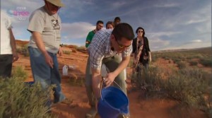
Don Prothero supervising Phil Robinson with a wholly-inadequate two-gallon simulation of the flood
He says on his blog, “… this demonstration was very effective, and caught the smug Phil and others completely flat-footed …” (I wonder if he was not happy that Phil questioned his uniformitarian claims.)
Prothero took the team to spectacular Horse Shoe Bend. He argued that the receding waters of Noah’s Flood would have flowed in straight lines, but since Horse Shoe Bend was a tightly curved meander, the Flood could not have carved it.
When the bucket of water was tipped out, the water mostly soaked into the sand, but the little that remained flowed in a fairly straight line before it too quickly disappeared—it did not meander.
A simulation is only useful if it represents what is being simulated. In this case it was misleading because it used an inadequate understanding of the magnitude and behaviour of the receding waters of the Flood. It also did not account for how the conditions changed as the waters reduced and as sea level dropped.
The evidence for the receding waters of Noah’s Flood flowing from the plateau can be clearly seen in the landscape (see Horse Shoe Bend, Arizona). One needs to have a wide-angled view of the topography using a tool such as Google Maps or Google Earth. The channels cut by the waters are dramatic—more than 30 km wide. The meanders including Horse Shoe Bend were cut by the greatly reduced final flows of the Flood as sea level dropped. Their course was controlled by the topography of the surface after the main flow had waned.
Don Prothero could make a better simulation by using a surface that was not so porous. Water won’t meander on a surface that is porous when it is quickly absorbed. A simulation also needs a surface that is not so sloped, and that contains small undulations—such as sand ripples on a gently sloped exposed beach. A small flow of water across the beach, provided it did not soak in, would meander along the low parts between the sand ripples, just like the section of canyon that contains Horse Shoe Bend.
Peter Scheele has an excellent paper on the carving of Grand Canyon by receding floodwaters in which he discusses different erosion patters, including those by flowing water and those by draining water and the different sorts of canyon shapes produced.


